
What If a Highway Ran Through the Infinite Corridor?
-
-
slice.mit.edu
- 2
Filed Under


As the United States’ most walkable city (not to mention the bikes), it’s difficult to envision an eight-lane highway running through Cambridge. But had some city planners and politicians gotten their way about 50 years ago, Interstate 695 would have created an inherently different Cambridge–and MIT campus–than what exists today.
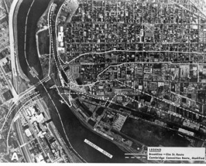
Interstate 695, better known as the Inner Belt, was a planned highway that would begin at Route I-93 in Somerville, run though Cambridge in Central Square, Cambridgeport, and the outskirts of Kendall Square, and eventually connect with the Central Artery to encircle much of Greater Boston.
The Inner Belt was first proposed in 1948 as the post-World War II population left cities for the suburbs. To combat population outflow, city politicians sought highways to provide temporary construction jobs and long-term access to city businesses.
From Wicked Local Cambridge:Wicked Local also notes that a Cambridge City Council-proposed alternative included moving the highway southeastward, which MIT opposed for “national defense” reasons.“The project would have displaced 1,541 households in Cambridge, 1,606 in Boston, 589 in Somerville, and 83 in Brookline. In Cambridge, it would have cut down Elm Street and Brookline Street before heading south over the Charles River.
In Cambridge, the city was divided. People who lived in the way of the proposed highway opposed the project, but the Planning Board, Harvard University, and MIT were all in favor, according to Tunney Lee, an MIT professor emeritus who provided technical assistance to the project’s opponents.”
According to the Cambridge Historical Society, opposition to the highway began in Cambridge and united towns and neighborhoods throughout Greater Boston. In 1970, Massachusetts Governor Francis Sargent ’39 ordered a three-year review of the plan, which would produce the first Environmental Impact Study in the United States. Sargent officially rejected the Inner Belt in 1971 and, using part of the proposed funds for the highway, approved plans to extend the MBTA Red Line from Harvard Square to Alewife in 1973.
While the Inner Belt wouldn't have made it as far as the Infinite Corridor, had it been built, modern-day Cambridge might be a radically different place. Would MIT and Harvard still be as successful as they are today? Can you imagine a Red Line that ends at Harvard Square? Let us know in the comments below or on Facebook.
For more information on the Inner Belt’s history, the Cambridge Historical Society is hosting “The Legacy of the Inner Belt,”part three of a three-part series, on Wednesday, April 25. Cambridge residents can also view past Inner Belt symposia on Cambridge Community Television.


Comments
Barry Cunningham
Mon, 04/23/2012 6:49pm
I hate to break it to you, but when I was an undergrad, the Red Line <b>did</b> end at Harvard Square.
<a href="http://www.flickr.com/photos/cunningba/1440799428/" title="Eastgate, Kendall Square, and Boston Skyline. Late Fall, 1967. by cunningba, on Flickr" rel="nofollow"></a>
Jay London
Tue, 04/24/2012 10:48am
Thanks for the comment, Barry. It's hard for recent grads to envisions no Red Line past Harvard Square!