
Guess What's Lurking in the CEE Basement?
-
-
slice.mit.edu
- 1
Filed Under


Like basements everywhere, the Civil and Environmental Engineering (CEE) lab in Building 1 contains long-forgotten objects. Six years ago, technical instructor Stephen Rudolph discovered two pristine metal instruments in their original wooden cases, identified by a label as US Army Air Force equi-angulators. Since nobody knew anything about these approximately 40-pound objects or how they ended up in the basement, he sent a photograph to the spring 2006 CEE at MIT newsletter in case alumni readers could provide details.
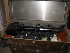 Responding quickly by mail, Albert Costanzo ’55 recounted how he operated an identical equi-angulator in 1946 as a 19-year-old member of the 7th US Army Air Forces Geodetic Control Squadron, 311th Photo Wing, Mapping and Charting. He explained how to collect data about the time and the positions of stars at many different locations around the world. “This information was then used to locate critical landmarks on aeronautical charts used by pilots and navigators,” he wrote.
Dragging a heavy instrument and its tripod to remote locations around the world required a three- to four-man group, Costanzo noted. “Often they were stranded and had to be rescued. Sometimes they had to bargain for safe passage when confronted by hostile natives.”
In between fending off danger, the soldiers set up the instrument on its tripod.
“The instrument was leveled, and mercury was poured into the [circular] dish to act as a reflecting surface,” wrote Costanzo. Using a star chart, a precise timepiece, and time checks provided by the BBC Greenwich shortwave radio station, they would do a series of calculations to record the exact time and location of stars.
“After recording 20 to 30 star observations over a 1.5-hour to 3-hour period, they would have enough data to send to the Computing Section of the 7th Geodetic Control Squadron back in the States. An aerial photograph of the control point was also sent with the data,” he said. More calculations determined the exact latitude and longitude of the control point.
“About 25 to 30 man-hours were required to compute the results of 20 to 30 star observations for each control point. These calculations were done by hand using a Marchant hand-cranked calculator and a slide rule.”
No matter how obsolete these instruments have become, the CEE equi-angulators deserved a better fate than being sold for scrap metal. After inquiries to numerous museums, in August 2012 one was shipped to the Smithsonian National Air and Space Museum in Washington, D.C., while the other headed to the National World War II Museum in New Orleans.
They are most welcome in their new homes:
Roger Connor of the Smithsonian wrote, "[The equi-angulator] is a wonderful fit with the content of our new Time and Navigation exhibition, opening in March 2013, which will explore the interconnections between improvements in timekeeping and positioning for navigation. The equi-angulator is a nice illustration that there was a robust celestial means of positioning in geodetic context before GPS."
Annie Tete, the STEM (Science, Technology, Engineering, Math) education coordinator at the National WWII Museum, considers the equi-angulator “an excellent example of a STEM-related artifact. Its development and use during WWII illustrates the importance of precision map-making long before the development of GPS technology. By illustrating the progression of technological advancements from the equi-angulator to the GPS, we can provide a context for studying applied mathematics, science, and geography.”
We are delighted that these beautifully preserved precision tools have moved from basement obscurity to an ongoing role in educating new generations.


Comments
khan
Wed, 10/10/2012 4:15am
great article the equi-angulators is quite impressive on that time and its really a good treasury with the massage of time because such thing is not seen now