
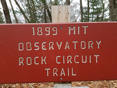
MIT’s Mysterious Observatory Rediscovered
-
-
slice.mit.edu
- 1
Filed Under


Update: Check out photos from the April 29 Park Serve Day at the Observatory.

Sketch of the original MIT Geodetic Observatory attributed to Charles H. WoodburyLast summer, Brian DeLacey and his wife set out on a mission: they wanted to find MIT’s Geodetic Observatory in the Middlesex Fells Reservation, located five miles outside of Boston. The 15 square foot stone observatory was built in 1899 by MIT to research geodesy, the study and measurement of the earth’s shape. Very few hikers have actually found the observatory, which lies at a high point within the Fells’ 2,575 acres and more than 20 miles of hiking trails, and, that evening, the DeLaceys came home similarly empty handed.
“The irony of course is here’s a place that was really put on this earth solely to help people navigate …and we couldn’t find it,” said DeLacey.
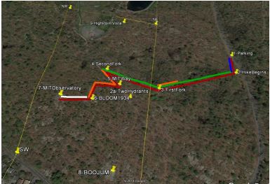
He partnered up with friend Bill Ricker to narrow in on the observatory’s location using early 20th century surveying maps and handwritten reports from the observatory with Google Earth, GIS, and GPS technologies. Afterwards, they created an MIT Trail using GPS waypoints for others to more easily visit the observatory.
At the turn of the 20th century, the observatory was a bustling field lab for MIT students and the community. It “is intended primarily to be used in giving instruction in the most refined methods of determining latitude and longitude and secondarily to be used in magnetic and gravity observations,” wrote MIT Professor George L. Hosmer in an 1899 article in Tech Quarterly.
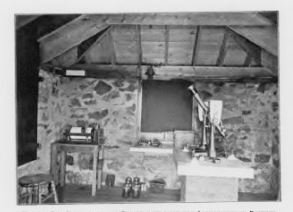
As a working lab, it housed advanced latitude, astronomical, and magnetic observation equipment including a transit instrument telescope, sidereal chronometer, chronograph, and magnetometer. Researchers were responsible for contributing to advances in the study 20th century surveying methods.
“I truly believe that the role that MIT played was absolutely crucial,” said DeLacey. “If they hadn’t done that, as crazy as the streets sometime are in Cambridge, you wouldn’t have any sense of where things were supposed to be.”
The observatory went out of use sometime in the 80 years since 1899 and 1970, when MIT’s Haystack Observatory was built. But little is known about why or when this happened. “There’s certainly more of the story to be told,” said DeLacey.
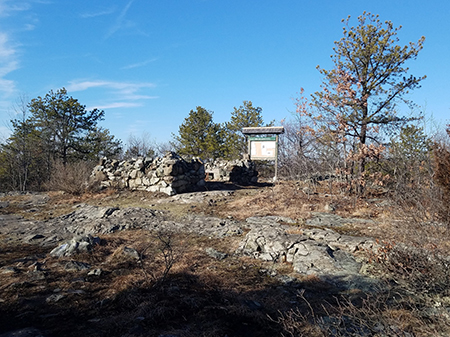
Currently, the observatory still has its stone foundation and sits on a high point in the Fells overlooking Boston’s skyline. Watch a fly over video of the observatory. Trees have grown into view and the walls and roof are now rubble.
With an upcoming community event scheduled for April 29, DeLacey hopes that the observatory can be revived as an educational site. “There’s inspiration for the next generation of students and innovators,” he said. “This may provide some guideposts for their future.”
Attend the April 29th community clean up event. Learn more about the observatory and its later spring rededication ceremony and download a map of the MIT Trail.


Comments
Fox
Fri, 04/21/2017 8:44pm
So this is a really well marked trail, and the observatory is labelled on the online topo map, as well as sign-posted from the trail head on Fellsway East (gate 53). It's about half a mile from the parking lot; the trail is admittedly rocky and steep, but it really doesn't offer the slightest navigational challenge.
This story of arduous rediscovery just doesn't match the facts. Is it some reverse-psychology attempt to interest people in finding it by making it seem hard? Did you copy a story about discovering some actually-hidden feature and switch the names?
anonymous_stub
Wed, 06/07/2017 9:40pm