
Media Lab Group Shows Safest Places to Bike and Where to Find the Most Shade
-
-
slice.mit.edu
Filed Under


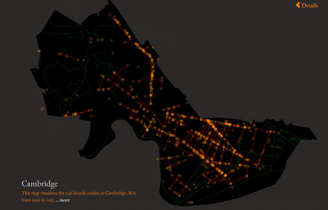 Police-reported bicycle crashes in Cambridge, Mass., 2010-2013. Image via You Are Here
According to the Media Lab’s Social Computing @ MIT team, maps are art and planning tools, simultaneously beautiful and useful, and a language unto themselves.
And each day for at least the next year, the group will unveil one specially-designed map that uses easily-accessible data for the purpose of helping make cities a better, safer place. The project, titled You Are Here, plans to eventually graph 100 different maps in 100 different cities.
To date, the project has produced 19 maps in 15 cities, including Cambridge, Mass., with street-level data on topics like permanent visas and bicycle crashes. Cambridge is represented on three maps: police-reported bicycle crashes from 2010-2013, independent coffee shops, and street greenery.
Based on data from the map, nearly 800 police-reported crashes took place in the four-year span, with the highest density of accidents occurring on Massachusetts Ave., Cambridge St., and Hampshire St. The group hopes that, by making this data accessible, Cambridge streets can become safer for riders.
From You Are Here:“Mapping where bike accidents occur might encourage cities to put separate bike lanes where there are lots of accidents. Mapping coffee shops walking sheds might help the aspiring coffee shop entrepreneur decide where to place her shop. And mapping greenery in the city might encourage people to plant trees where there are none.”
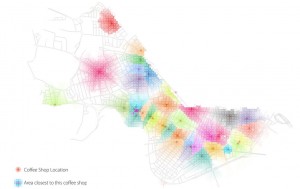 Independent coffee shops in Cambridge, Mass. Image via You Are Here
Potential Cambridge coffee entrepreneurs may want to consider the Cambridge Highlands or Strawberry Hills neighborhoods, which according to the map, have zero independent coffee shops. The highest concentration of indy coffee is near the neighborhood border of West Cambridge and Riverside and greenest streets can be found in West Cambridge near Memorial Dr.
The maps are formulated using a combination of information from Google, census data, police reports, zoning ordinances, open data, and APIs.
According to its website, Social Computing group integrates techniques in data mining and visualization to better allow people to collectively shape the world around them. The 11-person team has lived, is led by Kamvar and includes Salman Ahmad G, Ed Faulkner '03, MEng '04, Wesam Manassra '13, and Pranav Ramkrishnan '13.
Follow the MIT Alumni Association on Twitter at @mit_alumni.


