Citizen Mapping Aims to Save the Earth
-
-
slice.mit.edu
Filed Under


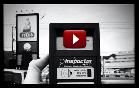
Sean Bonner began his company, SafeCast, after Japan’s Fukushima nuclear plant disaster in 2011. Worried about the lack of radiation monitoring and the potentially deadly levels of radiation near the plant, Bonner and a group of friends took a bootstrapped approach—duct taping a radiation monitoring Geiger counter to the window of their car and traveling around the country taking geotagged photos with an iPhone.
Their data demonstrated that areas the government evacuated people to were still too high in radiation, ultimately resulting in evacuees being moved to safer areas. SafeCast now houses the largest open set of radiation data, collecting more than 20 million radiation data points in 53 countries.
The Open Water Project, a newly developed project led by MIT Media Lab graduate student Catherine D’Ignazio and a number of academics and hydrologists, equips everyday citizens with affordable and accessible tools to monitor nearby rivers, lakes, ponds, and oceans. The project has developed Riffle, a tool for testing the conductivity, depth, and temperature of water at a fraction of the cost of current water logging tools.
Riffle, which acts like a fever thermometer, can tell if the water is not healthy, but does not perform costly diagnoses of the cause. D’Ignazio envisions people using several Riffles downstream from a factory or farm to test water quality or to assess the health of an entire river network. Development of an open data platform and community education is underway, and the project will launch a pilot at the Mystic River watershed this summer.
Open Water is housed at the Public Lab for Open Technology and Science. The lab’s Research Director Jeff Warren SM ‘10 talked about the lab’s mission to incubate start-ups focused on solving environmental justice and human health challenges through the development of open source tools. Read more about the Public Lab's participation at the White House Maker Faire.
Other speakers included David Manthos, who highlighted how his company Skytruth allows people to download free satellite images of environmental areas and get geospatial data alerts on the impact of issues like oil spills and fracking.
“People can see what’s happening in the world and have a part in the science of understanding,” said Manthos.
Watch video versions of the Citizen Mapping talks and other panels during the conference.


