Cape Cod Canal: MIT Models Data in the 1930s
-
-
slice.mit.edu
Filed Under
Recommended
Soon after the Pilgrims colonized Cape Cod, they realized that a canal cut across the seven-mile isthmus would eliminate the hazardous 135-mile sail around the Cape. After almost 300 years of discussions and five years of work financed by a wealthy New Yorker, the first Cape Cod canal opened to traffic in 1914. The privately-run canal lost money (it was shallow and expensive) and was purchased by the U.S. government in 1928. During the Great Depression it was widened and deepened, using hand labor as much as possible to increase employment; by 1940 it had become the widest (480 feet) sea-level canal in the world.
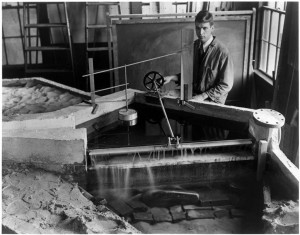
Two scale models created in the 1930s by MIT civil engineering faculty and staff provided essential data for this reconstruction. Supervised by Professor K.C. Reynolds and John Drisko ’27, the first model was described by The Tech in January 1933 as “the most advanced practice in modern hydraulic research in which problems are studied in miniature and the results transferred to the full natural size.” Even at a scale of five feet to a mile, the laboratory model stretched 41.5 feet. The normal 12-hour tidal cycle was condensed to just a few minutes in the lab, speeding up timed tests.
The canal connects Cape Cod Bay on the east with Buzzards Bay on the west. Since the average rise and fall of the Cape Cod Bay tide is five feet greater than in Buzzards Bay, and the ebbs and flows in the two bays occur three hours apart, water rushing from one bay to the other can create strong currents. The Tech reported, “Many captains of large ships avoid the canal because of the risk of being driven ashore.” The model tested the effects of installing a lock to tame these tidal currents and make the waterway safe for all vessels.
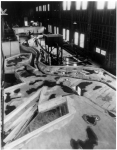
An enlarged Cape Cod model constructed in 1935 of concrete and sand was almost three times bigger at 115 feet long, including a 35-foot by 50-foot section devoted to the inlets and islands of Buzzards Bay. As the country’s largest tidal model of its time, this version made it possible to study the currents and wave motions of the canal in its present form and also to predict changes in the velocity of currents after widening and dredging.
Since the models gave people their first good look at the complicated underwater topography of the Cape, they proved to be popular displays for visiting dignitaries and at MIT Open Houses during the 1930s. Course I has continued to make models for testing large-scale public works, including the massive flood gates now being constructed in Venice for protection against frequent winter floods. See the ocean modeling research at the Program in Atmospheres, Oceans, and Climate for more.


